|
|
 |
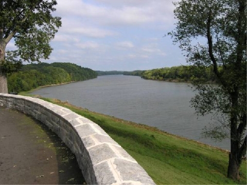
Old Hickory Lake
| |
With over 22,000 acres of water and 440 miles of shoreline, Old Hickory offers plenty of hiking, fishing, boating, skiing, and other lake activities.
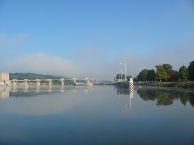
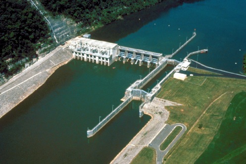
Old Hickory Lake was constructed by the U.S. Army Corps of Engineers beginning January, 1952. The dam was closed and the filling of the lake began June 11, 1954. The lock opened to navigation June 14, 1954 and electrical power began production April 5, 1957. The total cost of the project was $48,681,700.
The total length of Old Hickory Dam is 3,750 feet; 145 feet of that being the navigation lock, 2,870 feet of earth and embankment, 355 feet of spillway, and the balance of 380 feet consisting of the powerhouse intake section. At the dam, there is a lock that was constructed for navigation purposes which has a maximum lift of 63 feet from below the dam to above the dam, with a chamber size of 84 feet by 400 feet.
Construction of the dam took 460,800 cubic yards of concrete; 1,650,600 cubic yards of earth excavation; 169,000 cubic yards of rock excavation; 432,600 cubic yards of earth fill; and 18,900 cubic yards of rock fill and riprap.
T he elevation of the reservoir at maximum pool level, which covers an area of 22,500 acres, is 445 feet above sea level. The normal minimum pool, which covers an area of 19,550 acres, is 442 feet above sea level. The backwater length of the reservoir at the top of the gate level (mainstream) is 97.3 miles long. Old Hickory Reservoir at maximum pool has 440 miles of shoreline and contains 467,000 acre feet of water. The water shed area (the area of land from which the water feeds the lake) covers 11,674 square miles. he elevation of the reservoir at maximum pool level, which covers an area of 22,500 acres, is 445 feet above sea level. The normal minimum pool, which covers an area of 19,550 acres, is 442 feet above sea level. The backwater length of the reservoir at the top of the gate level (mainstream) is 97.3 miles long. Old Hickory Reservoir at maximum pool has 440 miles of shoreline and contains 467,000 acre feet of water. The water shed area (the area of land from which the water feeds the lake) covers 11,674 square miles.
Old Hickory Dam is located on the Cumberland River at mile 216.2, and is in Davidson and Sumner Counties, Tennessee, 25.5 miles upriver from Nashville. The counties surrounding Old Hickory Lake include Davidson, Sumner, Wilson, Trousdale, and Smith Counties.
|
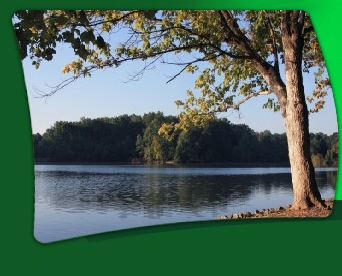
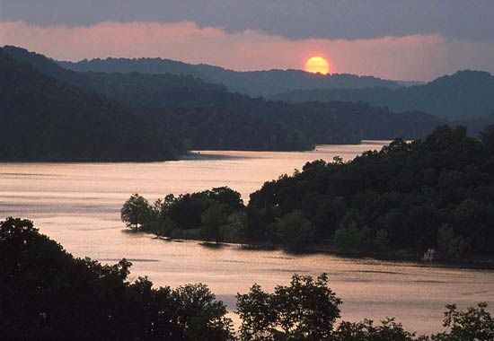
An Autumn Afternoon on Old Hickory Lake
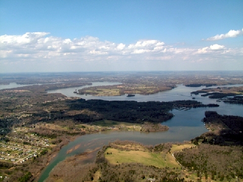
J. Percy Priest Lake
| |
J. Percy Priest Lake is an artificial lake in north central Tennessee. It is formed by J. Percy Priest Dam, located between miles six and seven of the Stones River. The dam (easily visible from Interstate 40) is located about 10 miles east of downtown Nashville and impounds a lake 42 miles long. The lake and dam are named for Congressman Percy Priest.
The lake covers portions of Davidson, Rutherford, and Wilson Counties and consists of 14,200 acres of water at summer pool elevation 490 feet above mean sea level. The water is surrounded by 18,854 acres of public lands; 10,000 acres are devoted to wildlife management. The site of the former town of Old Jefferson was inundated by the reservoir; the community was demolished in the early 1960s for the building of the dam.
The dam, powerhouse, lake, and public lands are operated and supervised by the U.S. Army Corps of Engineers' personnel under the direction of the District Engineer at Nashville. The Natural Resource Management Office maintains three campgrounds (Anderson Road, Seven Points, and Poole Knobs), eleven day-use/picnic areas (Anderson Road, Cook, Damsite, East Fork, Fate Sanders, Jefferson Springs, Nice's Mill, Overlook, Seven Points, Smith Springs, and Tailwater), and twelve boat launching ramps (Anderson Road, Cook, East Fork, Fall Creek, Fate Sanders, Hurricane Creek, Jefferson Springs, Lamar Hill, Mona, Nice's Mill, Poole Knobs, Seven Points, Smith Springs, Stewart's Creek, and Viverett Creek). Marinas at the lake include Elm Hill, Four Corners, Fate Sanders, Hamilton Creek, Percy Priest, and Nashville Shores. The lake is also home to a number of recreational organizations such as the Vanderbilt Sailing Club, the Vanderbilt Rowing Club, and the Nashville Rowing Club.
|
Cheatham Lake
Cheatham Lake is an impoundment of the Cumberland River with 320 miles of shoreline. It is 67.5 miles long and extends all the way from Cheatham Dam through Nashville to Old Hickory Dam. In its upper reaches, the lake generally consists of a deepened river channel and is often referred to as a river. However, water levels and flows in these upper reaches are also controlled by the dam.
The water is approximately 40 feet deep at the dam. Lake levels are controlled to provide a navigable channel with a minimum depth of 9 feet all the way upstream to Old Hickory Dam. However, deeper areas are present along the high bluffs found throughout the lake.
Surface water temperatures at the dam range from 36 degrees Fahrenheit in the winter to 84 degrees Fahrenheit in the summer.
The lock is open to recreational craft at no charge. However, barge tows and other commercial vessels have priority. The lock is open 24 hours a day, 7 days a week. A single lockage takes about 30 minutes.
Camping is permitted in only in designated areas. Lock A Campground provides 45 campsites with water and electrical hookups. Harpeth River Bridge Campground has 15 developed campsites but no hookups. Both areas have resident park attendants on duty during the recreation season. Base fees for campsites are $19-$23 at Lock A and $7 at Harpeth River Bridge. Camping elsewhere on public lands along the shoreline, including islands, is prohibited.
|
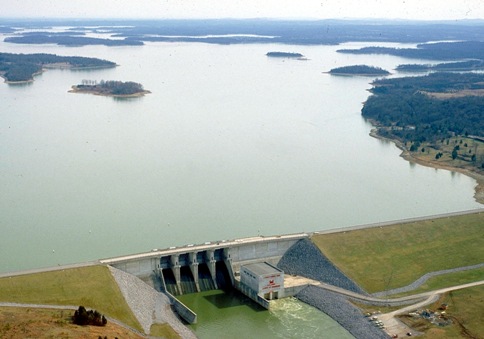
Center Hill Lake
DeKalb County is the home of Center Hill Lake, a 64 mile long reservoir with 415 miles of largely undeveloped shoreline and 18,200 acres of deep, pure water – the ideal habitat for many species of fish. The lake offers a wide variety of sporting opportunities including boating, fishing, water-skiing, camping, picnicking, hiking and swimming. Additional attractions located on the lake are Edgar Evins State Park and Center Hill Dam. The U.S. Army Corps of Engineers built the dam on the Caney Fork River in 1949, and the Corps still owns and maintains the entire area.
|
Dale Hollow Lake
Dale Hollow Lake is located in Tennessee and Kentucky and is surrounded by the Tennessee Counties of Clay, Overton, and Picket; and two Kentucky Counties of Clinton and Cumberland. The larger part of the lake is located in Tennessee.
The construction of Dale Hollow Lake was completed in 1943 for the purpose of flood control. In 1948, 1949, and 1953 power generating units were added by the U.S. Army Corps of Engineers for the purpose of power generation. Dale Hollow power generation plant is sufficient to supply a city of 45,000 people with electricity. The dam and power plant are located approximately three miles east of Celina, Tennessee.
Dale Hollow Lake consists of 27,700 acres of lake surface area, and 24,842 acres of surrounding land, totalling 52,542 acres and is one of the cleaner lakes in the United States. The lake has 620 miles of shoreline.
The average water temperatures of Dale Hollow Lake range from 45-80 degrees. The deepest area of the lake is in the main channel near the dam totalling 130 feet.
Dale Hollow Lake is one of the fewer lakes in Tennessee and our nation that provide an unobstructed view of nature and natural beauty at its best due to the restrictions of private boat docks and the removal of trees from the shorelines.
The quality of the water in Dale Hollow Lake is important for the Dale Hollow National Fish Hatchery located below the dam. The hatchery is the largest federal trout hatchery east of the Mississippi River, producing 1.5 million trout per year, totalling 300,000 pounds. These trout are distributed between Alabama, Georgia, and Tennessee. While visiting Dale Hollow Lake the hatchery offers access to visitors from 7 a.m. to 4 p.m.
Located on Dale Hollow Lake are two famous historical sites. The home place of Sergeant Alvin C. York, the famous WW1 hero, is located in Pall Mall, Tennessee. The other is the birthplace of Cordell Hull which is located near Byrdstown, Tennessee. Cordell Hull was a great statesman and is remembered as a recipient of the Nobel Prize and the Father of the United Nations.
Dale Hollow Lake is a popular wintering area for the Bald Eagle, our American symbol. These beautiful birds can generally be observed from mid-December to mid-February.
Dale Hollow Lake attracts millions of visitors per year and offers many activities including fishing, boating, skiing, camping, hiking, horseback riding, hunting and much more. The mild climate and long recreation season make this and other Tennessee Lakes popular vacation spots. Scuba diving is a popular sport on Dale Hollow lake; divers are thrilled with the absence of trash and other debris in the lake.
|
Cordell Hull Lake
The Nashville District U.S. Army Corps of Engineers welcomes you to Cordell Hull Lake. The lake provides a variety of outdoor recreational opportunities for millions of visitors each year. Because of the temperate climate and relatively long recreation season, visitors have numerous activities from which to choose, including: fishing, hunting, camping, picnicking, boating, hiking, horseback riding and other numerous ways to enjoy nature.
Cordell Hull Lake provides boaters with a wide variety of opportunities to enjoy their respective recreational interests. Our 11,960 acres of water offer an opportunity for all types of recreation. Canoes, Sailboats, Fishing and Hunting Boats, Pleasure Boats, and Personal Watercraft all share the waters, so each boater has a responsibility to respect other boaters and practice good boating ethics and launching etiquette.
With 381 miles of shoreline and 22 boat-launching ramps, Cordell Hull Lake offers a fishing opportunity for anyone with or without a boat. Cordell Hull Lake provides a desirable cold and warm water fishery. Adequate cold water is present year-round; this water is discharged from the hypolimnion of Lake Cumberland and Dale Hollow Lake.
Roaring River and its tributaries provide the lake with adequate warm water. Roaring River and its tributaries, Blackburn Fork and Spring Creek are excellent smallmouth bass and rock bass streams.
|
Cumberland River
| |
The Cumberland River is an important waterway in the Southern United States. It is 688 miles (1,106 km) long. It starts in Letcher County in eastern Kentucky on the Cumberland Plateau, flows through southeastern Kentucky and crosses into northern Tennessee, and then curves back up into western Kentucky before draining into the Ohio River at Smithland, Kentucky.
The Cumberland River is a wild river above the headwaters of Lake Cumberland. Cumberland Falls, a 68-foot waterfall on this section of river, is one of the largest waterfalls in the eastern United States and is the only place in the Western Hemisphere where a moonbow can be seen. Most of the river below Lake Cumberland's Wolf Creek Dam is navigable because of several locks and dams. A 90-mile section of its Big South Fork is protected by the National Park Service as Big South Fork National River and Recreation Area.
Dams at various locations of the Cumberland River have created large reservoirs for recreation such as Lake Barkley in western Kentucky and Lake Cumberland (the deepest lake in the Tennessee and Cumberland river valleys) in southern Kentucky. Cordell Hull and Old Hickory Lake to the east of Nashville and Cheatham Lake to the west. Laurel Lake, on the Laurel River in southern Kentucky, the Dale Hollow Reservoir on the Obey River in northeast middle Tennessee, and Percy Priest Lake on the Stones River in Nashville are each created by dams just upstream from their respective confluence with the Cumberland River.
|
The Duck River
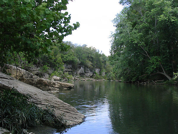
As the Duck River makes its way some 270 miles on its journey through middle Tennessee to the Tennessee River, it passes though some of the state’s most scenic pastoral lands. From its origin in the western part of the Highland Rim, it flows in a westerly direction across the Nashville Basin and the Western Highland Rim before emptying into the Tennessee River. On its journey across middle Tennessee the river passes by pastures and agricultural lands, as well as numerous tall bluffs and steep rocky cliffs and forested banks. The vegetation along the river can be generally characterized as bottomland and riparian hardwoods, mixed hardwoods, cedar forests, brushy thickets, and limestone cedar glades.
The Duck River was designated as a state scenic river because of its scenic, ecological, cultural, and historical values. Designation as a state scenic river enhances the ability to protect these values, and the many species of rare and endangered plants and animals that make their home there.
The Duck Rivers is clearly one of the most biologically rich and diverse rivers in North America. Over 500 species of aquatic plants, fish and invertebrates have been documented in the section of the Duck River that has been designated as a state scenic river alone, including at least 39 mussel and 84 fish species. Indeed, the Duck River contains more species of fish than all of Europe. Anglers enjoy catching smallmouth bass, spotted bass, rock bass and catfish from boats and from the river’s banks.
A good example of this diversity is the birdwing pearly mussel, which depends on a particular species of fish, the banded darter, to host its young. Therefore, the protection of this fish species is critical to the survival of the birdwing pearly mussel. To protect this and other important mussel populations, the entire Duck River has been designated as a mussel sanctuary by the Tennessee Wildlife Resources Agency. This designation prohibits commercial harvesting of mussels or any disturbance to their habitat. The Duck River has already lost at least 35 species of mussels through the years, mainly due to development, and agricultural, chemical pollution and effluents. There are now just 34 mussel species living in its waters.
|
|
|
|
|
|
|
 |
|
|